


What if we ”speak with our eyes” of Israel’s past? There is a visual history over and under the surface, spoken by the land and its stones and by all the civilizations that have arisen there. Israel is a sophisticated and manipulated palimpsest. Extensively covered by the media, debated by nations, claimed by religions, it is also a case study about the phenomena of empires. By visually highlighting Israel’s vast archaeological repertoire, its architecture and its ruins, I question how they are used today in the discourse of the Israeli-Palestinian situation and the future of the country.
In the preceding pages, you have seen images containing, in one single frame, sediments of periods covering thousands of years and numerous governmental systems. For example, around a small private aerodrome near the ancient city of Be’er Sheva, airplane hangars dating from the British Mandate period (1920–1948) are scattered. Over Zion Gate in the old city of Jerusalem, a surveillance camera scrutinizes our age, itself embedded in stones from the reign of Sulei- man, and pockmarked by bullet holes from the 1948 war. Finally,in the ruined Palestinian village of Lifta, one can see the light of the construction site of a future rescue exit tunnel from an underground emergency nuclear bunker of the Israeli parliament. Such cases open a window through time on a landscape so familiar that we do not question it anymore
Israel is overloaded with sediments of past empires. More than half of the current IDF (Israel Defense Forces) strongholds rest on the ruins of military sites of former empires. The recycling of these spaces, from one conqueror to the next, shows how most empires tried to conquer and rule this land, with one similar outcome: they eventually failed. Dozens of excavated archaeological strata tell this complex multicultural saga—ironically enough, the remains are here to remind us that no human construct is everlasting. My images of these vestiges of occupation are a platform for discussion about the legitimacy and efficiency of imperialism and its use of power.
The camera unearths testimonies from the past and shows a different perspective. It reveals inconvenient truths and explores the landscape as a place of amnesia and erasure. It exposes Israel as a strategic site where the past has been buried and history veiled with natural beauty highlighting Adorno’s remark that “the beautiful in nature is history standing still and refusing to unfold.” Every cultural struggle over territory involves overlapping memories, narratives and physical structures. Edward Said underlined this in his book, Invention, Memory and Place, stating that memory, and its translation into history, is far from being neutral. It touches on questions of identity, nationalism, power and authority. Memory is used by nations to construct loyalty to country, tradition and faith.
I am pointing my camera at the landscape in order to dig and explore a reality of Israel behind the headlines and the touristic adoration, to reveal the landscape as a cultural force, an instrument in the construction of national and social identities. Only by under- standing the mix of geographical landscape with historical memory can one understand the persistence of the conflict and the difficulty in resolving it.
Sigmund Freud, in Civilization and Its Discontents, uses the analogy of Rome to explain that it is overwhelming, hence impossible, that each building and statue from all periods of Roman historyexist simultaneously in our consciousness. However, time has come to open our eyes to the many realities and the various antagonistic narratives that cohabit on the Israeli landscape. What can be shown photographically that would express this question of layering of narratives? How does the experience of ruin—and ruin upon ruin— appear today in Israel?
W.J.T. Mitchell writes in Landscape and Power: “. . . the landscape looks back in some way at its beholders, returning their gaze with a blank, impassive stare, its face scarred with the traces of violence and destruction and (even more important) with the violent constructions that erupt on its surface. . . . The landscape becomes a magical object, an idol that demands human sacrifices, a place where symbolic, imaginary and real violence implode on an actual social space. . . . The fantasy has now been realized in an idolatry of a place, a territorial mysticism enforced by bullets and bulldozers. The challenge is to sound out this idolatry, to unbind its fascination.”
This photographic document points out opposing narratives and strays away from one-sided simplistic views. My intent is to offer a stage where viewers can think about new relationships between the different histories and identities, assembled and disassembled in the wake of the creation of Israel. It is an incitement to open a critical and civic discussion about this country as a place where different perspectives existed and still exist, and to reflect on new possibilities today.
Stones are mute. We learn according to what we seek. Geologists read the layers of sediment and discuss climate changes. Archae- ologists look for construction fragments and the marks made by tools as signs of human life and evolution in work and building skills. Military historians seek the vantage points from which gen- erals viewed their battlefields and troops entered combat. Poets imagine who stood here and held this rock. Was it part of a home in which children were conceived and born? Was this rock part of an altar and for what religion? Whose blood has time and weather worn away?
Shai Kremer has focused his camera on the ever-present ancient stones in Israel relative to the cyclical claims of governments and their military forces. How have politicians perceived and shaped the land and to what military purposes? Kremer is aware that as claims on the region shift, prior histories fade or are actively, even brutally, re-composed. Which histories are remembered and which are forgot- ten are conscious decisions that are also affected by future plans and anticipated needs. In describing much of his work, he chooses the word palimpsest, “a manuscript on which the original writing has been effaced to make room for later writing, but of which traces remain.” By substituting “land” for the word “manuscript” and treat- ing the word “writing” metaphorically, he creates a new, applicable definition. After researching the traces encountered, his captions enrich the faint remnants, filling in missing histories. For instance, his caption for the photograph of Tel Nitzana identifies the opposing
cultures that have ruled this one place: Hellenistic, Roman, Byzan- tine, Arab, Crusader, Turk, British, Palestinian, and Israeli. In other texts, he focuses on the wars that have raged across the terrain over the centuries and in very modern times.
As a recent visitor to Israel, I understood that, as Kremer points out, one’s understanding of places can also depend on one’s tour guides and what they want us to notice and remember. But we all have our personal histories; I brought my own research on war and place to their recitations. I can understand the reverence with which the Jewish martyrs of Masada are held and respect their choice of death over cer- tain slavery, yet their decision exists simultaneously within the histories of all those who have chosen suicide over enslavement or certain death at the hands of the enemy. There are times when military suicide has nothing to do with any goal greater than the personal decision to deny the enemy the satisfaction of inflicting death or imprisonment; includ- ing such famous examples as Mark Anthony, Cleopatra, Adolf Hitler, and Hermann Goering. And sometimes suicide is a military tactic. Spies and servicemen on high-risk missions are routinely given cyanide pills as an alternative to capture. Then, there are those battles which,as military historian Jeff Hunt explained, end with one side choosing “the reasons for living over life itself’ and sacrificing their lives to defend their reasons for living. The men fighting at the Texas Alamo in the war for independence against Mexico died fighting in the faceof certain death rather than surrender. And so did the Spartans against the Persians in the battle of Thermopylae.
I do not wish to diminish the bravery and honor of the Jewish soldiers and their families at Masada, but to support Kremer’s case for the importance of historical context in fully understanding a place or an act. Very few actions are unique; most have precedents. Patterns should be analyzed and understood. Kremer’s pictures and the attendant texts serve primarily to inform, to evoke discus- sion, and to remind us of our responsibility to look for traces that can bring a deeper understanding. His pictures’ powers to engage the viewer are equally important. His stark framings of seemingly mundane locations appeal to the eye and stimulate interests where we might otherwise have passed them by. As Kremer writes, “Only by understanding the mix of geographical landscape with historical memory can one understand the persistence of the current conflict and the difficulty in resolving it.”
Anne Wilkes Tucker is a renowned American museum curatorof photographic works. In 1972, she received an M.F.A in Photo- graphic History from the Visual Studies Workshop, Rochester, NY, studying under Nathan Lyons and Beaumont Newhall. Tucker has worked for the Museum of Fine Arts, Houston since 1976, when it possessed virtually no photographs.
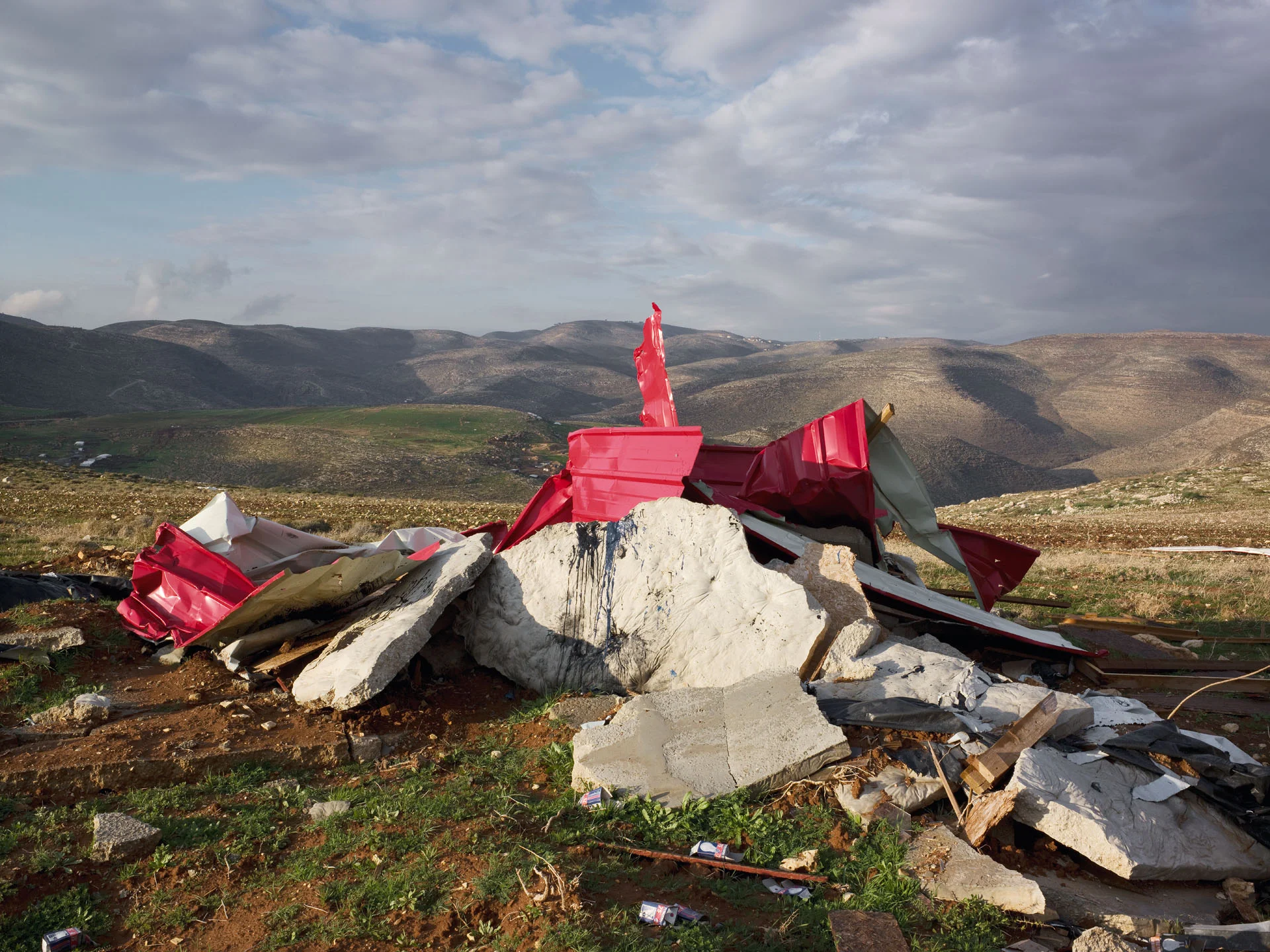
The destruction unfolding in the photographs in the last chapter of this book did not occur with the swish of an ax, nor was it restricted to one specific event in time. An unceasing, ongoing destruction, it is not concluded and sealed by the resulting archaeological mound— which is registered in almost every photograph—a mound that continues to boil like seething lava. In every such archaeological mound one may read not only traces of the past, but also the way in which the “regime-made disaster” conducted through spatial violence toward the non-Jewish population in Israel is inscribed in the landscape. The photographs do not record “ruins” or “debris”. These are general and rather abstract terms, which generate, in our minds, dissociation between destruction as an act and the resulting ruins, as if the ruins sealed the act of destruction and were but a by-product, which was not inflicted by man.
Kremer’s photographs provide a concrete database indicating that “ruins” are an integral part of the act of destruction; they are managed as part of a policy which goes far beyond the specific structure defined by the regime as one “intended for demolition”. In one of the photographs, the rubble appears to have been carefully gathered and attached as in a three-dimensional jigsaw puzzle whose parts form a perfect cone standing stable on the ground. For those unaware that the destruction of this house— like any other house—is part of a policy of ongoing domination of the non-Jewish population in Israel, the cone’s distinguished, “made” form conveys the feeling that “things are under control”,
that what is at stake here is not neglect, but rather renewal, a part of a restoration project. For members of the immediately concerned population, the one whose houses are being demolished, however, each stone fragment is like an arrow piercing the heart, a reminder that any day her or his house too might be destroyed, and that every site remodeled via destruction guarantees continued destruction and its ongoing emergence as “self evident” for the dominating population.
In each of the photographs one may discern the way in which the destruction is modeled and managed. In one instance, the shreds of the house are blended with the soil, generating a new topography in a spacious expanse from which it is already hardto reconstruct how the landscape looked prior to the destruction; in another, the structure’s “lumps” burst forth from the sea after they were densely imprinted along the shoreline in the hope that their traces might sink over time and assimilate into the coast expanded thereby. In yet another, at first sight the fragments appear as if they were left in place without anyone toiling to arrange them, but a closer look reveals that they were carefully arranged, concentrated on the margins of the park erected on site as its antithesis, a park whose verdancy and state-of-the-art facilities were intended to intoxicate those who may want to conceptualize the destruction for what it is—destruction—and to make them see the benefit in destruction, it being a means to renew the city’s appearance.
In each of the photographs one may reconstruct a differentiated manifestation of destruction in the public sphere. This is not an exceptional, localized destruction which may be given civilian justification—a part of a plan intended to improve the lives of the inhabitants who share the space in which it takes place—but rather systematic destruction violently enforced on one residential group only, which can be viewed as a part of an ongoing form of domination over them.
Since its establishment in 1948, the Israeli government has systematically demolished some 300,000 houses. Such demolition must not be measured by individual units, each to itself, but rather by the cry emanating from it, a cry which, instead of being heard as what it is—a call to destroy the regime which destroys its residents’ homes— divides the dominated population between the Mediterranean and the Jordan River into those whose soul flinches at its sound and who hear its echo whenever a stone is pulled out of a house, and those who are oblivious to it, disregarding it completely or silencing it with the excuses and justifications given by the regime to its acts of demolition. The imprint of the destruction in the landscapes photographed by Shai Kremer in Jerusalem, the Negev, Jaffa, and the Occupied Territories enables reconstruction of the manner in which the regime attempts to weaken and disrupt the non-Jewish population’s holdon the landscape, and to defamiliarize the landscape that population constructed over centuries.
Dr. Ariella Azoulay teaches visual culture and contemporary philosophy, is an author of several books including Civil Imagination: The Political Ontology of Photography (2011, Verso), The Civil Contract of Photography (2008, Zone Books), and Death’s Showcase (MIT Press, 2001, winner of The Infinity Award, ICP), and is a director of documentary films.
There is a land between the Jordan River and the sea where two nations dwell, one within the other, without a border dividing them. One nation was exiled two millennia ago and has returned to its homeland from the ends of the earth; the other has always lived there. Both claim ancestral rights to it. The former established a state in it; the latter never had one. The members of the former have political rights and elected institutions, they live in relative comfort in a regime which is democratic as far as they are concerned; their state is a national home for their people, and its citizens are protected by a strong army. The members of the latter lead a wretched life under occupation; they are largely uneducated, lack political rights, are devoid of representation, and their human rights are often violated.
In 1947 the United Nations General Assembly resolved that both nations have ancestral rights to the land, and therefore—they must share it. The members of the former—based on the Partition Plan, inter alia—indeed declared the establishment of their state, the State of Israel, in 1948; the members of the latter, on the other hand—in collaboration with their brethren—declared war on the nascent state. Bloody on both sides, the war ended with the latter’s defeat. In 1967, the Arab countries tried again to subdue Israel. That war ended six days later with Israeli military domination over the West Bank, Gaza Strip, and the Golan Heights.
This was the cue for an Israeli settlement drive in these territories. Jewish settlements were erected in the West Bank, Gaza, and the Golan Heights, introducing juridical as well as political dilemmas. From the judicial aspect, most of the countries in the
world hold that Israeli settlement is forbidden by internationallaw, by virtue of the Fourth Geneva Convention, a view also stated by the advisory council to the International Court of Justice in the Hague on the “Separation Wall” case. The Israeli Supreme Court has not decisively ruled that settlement is legal, yet gave it de facto legitimacy. In practice, some 123 settlements, which Israel regards as legal, were established in the West Bank, as well as more than 100 so-called “outposts” or settlement points, which are the beginnings of settlements, and hundreds of back-to-back neighborhoods—developments adjacent to older settlements—were also set up in the West Bank, most of them illegal, even according to the Israeli law applying in the West Bank. The settlement points and developments were generally set up with the financial support of Israeli government ministries, and with the aid of Israeli organizations and public authorities, although their establishment was against the Israeli law and the decisions of the Israeli government itself. This reality negates application of the fundamental principle of the rule of law, therefore harming Israeli democracy.
The Israeli settlement enterprise in the West Bank, however, introduces an even graver challenge to the State of Israel, which projects on its future and threatens its very existence in its original format—as the nation-state of the Jewish people and as a democratic state. There is no border between Israel and the West Bank, and the Israeli and Palestinian settlements are intertwined. Effectively, the bulk of the territory is under Israeli control. This domination over the territories of both pre-1967 Israel and the West Bank—a situation whereby the population of one nation has real political rights, while the other people is devoid of rights and lives undera military regime of occupation—undermines Israel’s democratic regime. Granting political rights to the entire population, both Israeli and Palestinian, however, is bound to threaten the Jewish majority in the state of Israel, thus changing the original formula of the State, which will cease to be the national home of the Jewish people. Separation from the West Bank is, thus, an Israeli interest rather than a “concession” to the Palestinian people. Such a move is primarily intended to preserve Israel’s essential image as the nation state of the Jewish people living under a democratic regime and to guard its fundamental values.
This, however, is not the last of the occupation’s evils: it also encourages terror, “triggering” vile acts of violence carried out by Palestinian suicide killers against Israeli civilians and soldiers, as well as Jews in general. The continued occupation inflicts a harsh blow on members of another people, casting an ethical stain on Israel, which perpetuates it. The settlement enterprise has caused a deep rift in the Israeli public, a rift that led to the assassination of Prime Minister Yitzhak Rabin in 1995. The desire to continue the occupation in order to expand the settlements casts a shadow on the ability of the Israeli democracy to implement its elected government’s policy if that policy opposes the worldview of those siding with the settlements. The more Israel’s democratic profile is eroded, so its international status is undermined, to the point of real harm, even to the very legitimacy of its existence.
The only solution which best serves the interests of both parties is that of “Two States for Two Nations”. Such a solution will leadto a peace agreement as part of which the boundaries of the Stateof Israel and of the future Palestine will be delineated. Israel will withdraw from the West Bank; under Palestinian agreement, it will annex some of the settlements to Israel in exchange for territories from Israel to be transferred to the Palestinians. The Palestinian state will be demilitarized; international forces will be deployed in its territory, and security arrangements will be set to ensure Israel’s future existence and safety. The problem of the Palestinian refugees from 1948 will be solved, largely, by means of monetary compensation. Special arrangements will be made for sites of special significance in Jerusalem, and its partition into Jewish and Arab quarters.
Continued Israeli construction in the Occupied Territories is bad for Israel since, at best (if a peace agreement is feasible), Israel itself will demolish what it built to sustain its vital interests. In the worst case scenario, the erected settlements may well destroy the existence of the state of Israel as the nation state of the Jewish people and a democracy. Hence, stopping construction in the West Bank is a vital constructive act for the sake of Israel’s future.
Talya Sason worked for 25 years in Israel’s State Justice Department as a state prosecutor and senior government attorney. She worked in the Occupied Territories and for the Supreme Court, in charge of representing West Bank citizens. At Ariel Sharon’s request in 2005, she investigated and authored a report on illegal settlements and outposts: a foundational document on the matter.
A Crusader maxim has it that “a ruined fortress is a fort half built.” Indeed, most of the ancient ruins in the Holy Land perpetuate empires and regimes that once ruled the land, bearing witness to fortresses erected on the ruins of earlier structures; only a small part of the stones whisper the daily life of the country’s ordinary people. Walls, infrastructure, and military training facilities all inscribe a spatial history, which, like the written history, is always the history of the strong. Writers and historians lengthily depict the chronicles of capital cities and fortresses, and the heroic deeds performed in them, whereas the life cycles of generations of ordinary village and town dwellers remain inconsequential, and their material culture is unworthy of mention. The ordinary man constructs buildings which cannot withstand the ravages of time. Victors alone can erect monuments that will last.
Empires strive to perpetuate themselves on paper monuments too, particularly on maps, which bear names they invented. In his lyrical way, Jorge Luis Borges quotes from a fictional Spanish book from 1658 on this aspect of cartography:
“In that Empire, the Art of Cartography attained such Perfection that the map of a single Province occupied the entirety of a City, and the map of the Empire, the entirety of a Province. In time, those Unconscionable Maps no longer satisfied, and the Cartographers Guilds struck a Map of the Empire whose size was that of the Empire, and which coincided point for point with it. The following Generations, who were not so fond of the Study of Cartography as their Forebears had been,
saw that that vast Map was Useless, and not without some Pitilessness was it, that they delivered it up to the Inclemencies of Sun and Winters. In the Deserts of the West, still today, there are Tattered Ruins of that Map, inhabited by Animals and Beggars. . .” 1
Photography has replaced pen and ink map-making in perpetuating the sense of victory. Kremer’s photographs are accompanied by a brief caption congruent with the archaeological-scientific chronology of Eretz Israel/Palestine. This chronology traces some of the empires that have conquered the land: Persian, Hellenistic, Roman- Byzantine, early Arab, Crusader, Mameluke, Ottoman, and British. Thus, the history of the country is perceived as the history of rulers from distant empires. These designations were set during the British Mandate period in a manner typical to European colonial powers that strove to adapt the history of the colonies to familiar frames, dis- regarding local events and periods of special significance to the lands they conquered and to their local heroes.
This chronology met with the needs of European and Zionist scholars whose interest lay mainly in the study of traces that could shed light on the biblical era, the former in a religious-Christian context, and the latter in a national context. The ongoing, local human activity was not considered worthy of investigation, recording, preservation, and protection as it was deemed “primitive,” at best serving to illustrate the lives of biblical figures.
Modern scholars who engaged in the study of the archaeology and history of overseas colonies embarked on a process of re-evaluation of the attitudes prevalent during the colonial period, admitting to the grave distortions introduced into the history of the colonies; these distortions resulted from Eurocentric attitudes, which disregarded and eliminated the traces of the natives’ past and the material culture of the indigenous peoples. Following this re-evaluation, native American, Aborigine, and native African sites are being studied and restored, and a new history has been written, focusing on the organic chronicles of those regions which heretofore has been but a marginal appendix to the history of European nations.
Israel is still dominated by the old narrative. Hence, the still standing monuments from the past are all but an innocent collection; they are a tendentious cluster recounting the story of the Israeli vic- tors. One day, the inhabitants of the Holy Land too will realize that every human activity manifested in the creation of physical objects is worthy of attention, regardless of the identity of its makers and the state of one’s hostility toward them. That which we have inherited from God or from past generations, we must pass on, undamaged in quality or diversity—enriched by our own contribution—to future generations. In the meantime, a beholder of the photogenic monuments of the past should hear the whisper of everyday life in the background of millennia eroded by time.
1 Jorge Luis Borges, “On Exactitude in Science” in Jorge Luis Borges: Collected Fictions, trans. Andrew Hurley (London: Penguin, 1998), p 325.
Meron Benvenisti is an Israeli political scientist who was Deputy Mayor of Jerusalem under Teddy Kollek from 1971 to 1978 and administered East Jerusalem and its largely Arab neighborhoods. He wrote a column for Haaretz for many years and has written several books.
There are numerous deserted military camps found throughout the country, which are an environmental eyesore. These camps mustbe seen against the broader backdrop of the prominence ascribed to security on the national agenda, and especially in view of the scope of security areas, their deployment throughout the country, and their implication on Israeli space and environment.
Driving on Israel’s roads or wandering about the country, one feels as if one were in a land like any other. A closer look, however, reveals that this is not the case. The scope of zones and expanses intended for security use in Israel is extremely extensive. At the beginning of the country’s 7th decade, of an area of approximately 22,000 sq. km within the borders of the Green Line (which represent the 1949 armistice line), East Jerusalem, and the Golan Heights, the security establishment holds—mainly through the Israel Defense Forces (IDF) and the government defense industries—some 40%of the territory, which is allotted for camps, facilities, training and experimenting grounds, and other security-related needs.
The imprint of the physical security presence is felt in diverse ways, in various dimensions, throughout the country—in the north, center, and south; in cities, rural areas, as well as open spaces. More- over, the security establishment restricts civilian construction and activity in additional areas: extensive portions of the civilian sphere seized in an emergency serve the military for deployment of forces as well as weapons systems, headquarters, and electronic command and control installations. Hence, the Israeli security establishment has
great impact, in diverse ways, on more than half of the state’s sovereign territory.
The scope of security areas expresses military needs and a setof (strategic, systemic, and tactical) considerations, land, economic and technological options, settlement conditions and environmental limitations, as well as historical circumstances. Their creation, since the country’s nascent days—individually and as a whole set—was not the result of orderly planning, but rather derived from the “British inheritance,” from security and political events which could not have been foreseen in the long run, as well as from the demographic, economic, and social transformations and the recognition of factors pertaining to environmental quality in recent years.
Furthermore, the security establishment also dictates, to a large extent, the uses of air space and large portions of the maritime space, and controls the electromagnetic fields. Bearing in mind that the IDF is the sovereign force in Judea and Samaria (excluding those parts under the Palestinian Authority), one may conclude that more than three quarters of the territory between the sea and the Jordan are directly or indirectly controlled by the IDF. The territorial dimension of security in Israel is a unique phenomenon for which it is hard, perhaps impossible, to find equivalents elsewhere.
1 This refers to the military infrastructure built by the armed forces of the United Kingdom in the early 1940s, before the establishment of the State of Israel, when Western Palestine-Eretz-Israel was under the Mandatory government. Initially, fortified police posts (the “Tegart forts”) were erected as part of the lessons learned from suppression of the Great Arab Revolt of 1936-39. The bulk of Britain’s military infrastructure was constructed during World War II, as part of the UK’s preparations to protect its possessions and strategic needs in the Near East and
in Western Palestine . This infrastructure included an alignment of camps and airports which formed a rear guard for the Allied Forces that fought in the Near East. At the end of the war, the scope of the British army in Palestine had not changed, nor had the infrastructure which served it. During those years, besides the maintenance of its presence in this realm, the major task of the British army units was to assist the Palestine Mandatory government in enforcing its authority and maintaining the law and order, following the renewal of the struggle by the Jewish Yishuv (community) against it.
Dr. Amiram Oren, researcher, lecturer and author of numerous publications has been specializing in the geography of defense and its research for over two decades. His book, A Land in Uniform – Territory and Defense in Israel, written together with Rafi Regev, was published in 2008.
A quote by David Ben-Gurion is written on the wall. “Every Jewish mother should know that the life of her son is in the caring hands of the proper general.”
An unrecognized Bedouin village located between Rahat and Be’er Sheva, in a location that the Goldberg commission deemed outside of the areas allowed for the Negev Arabs. It has been demolished numerous times; the inhabitants begin rebuilding after each demolition.
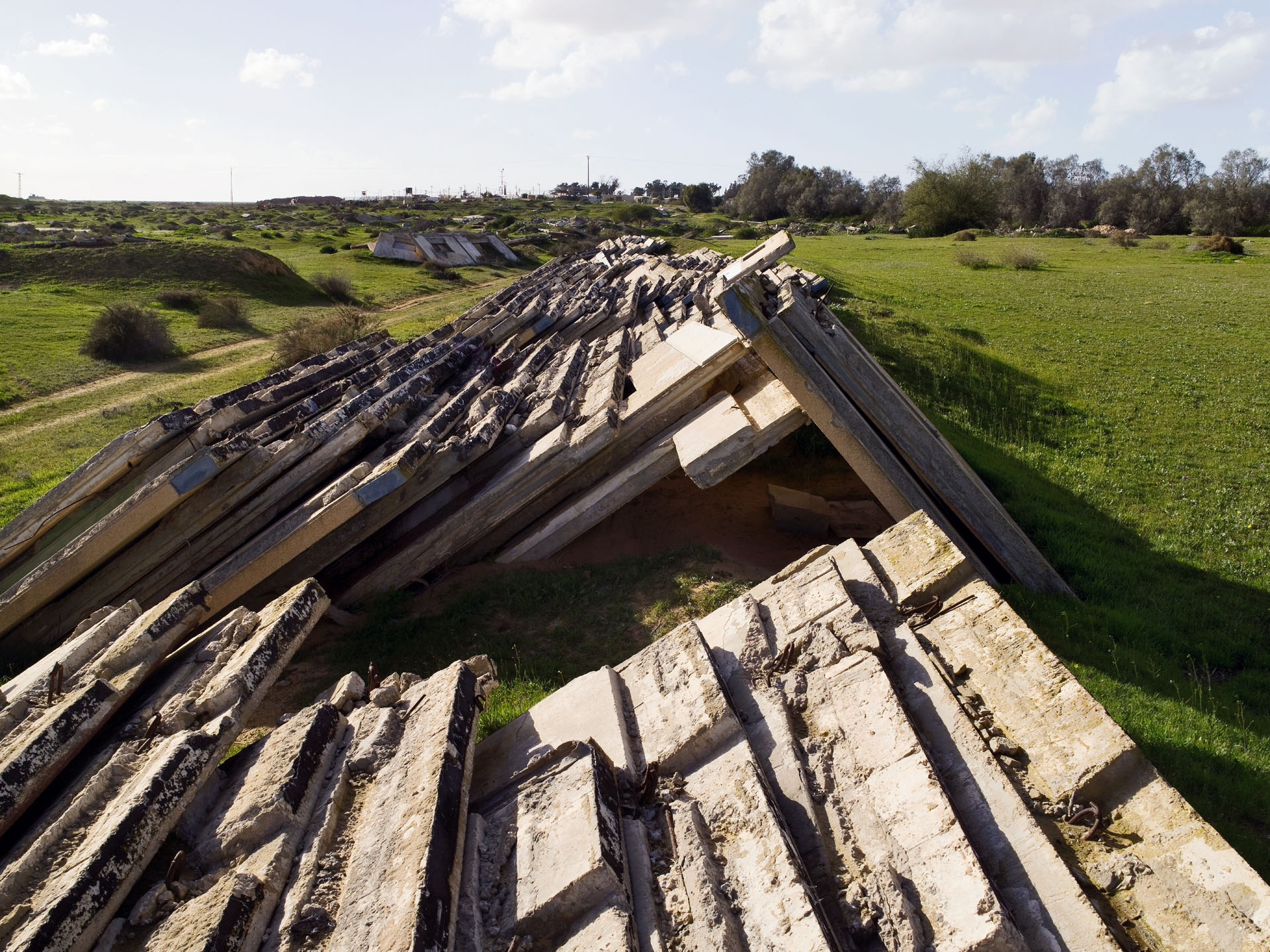
Yamit was a settlement of roughly 2,500 people in the northern part of the Sinai Peninsula and was established during Israel’s 1967 occupation. Menachem Begin decided to destroy the settlement when withdrawing from Sinai. The walls from the prefabricated houses were moved from their original location to a location inside Israel, northeast of Gaza.
Named after Esther Galia who was murdered at the Rimonim junction, this illegal outpost was evacuated in May 2009 by the IDF forces but was afterwards resettled. In January 2010 it was destroyed again by the IDF, resettled and then evacuated and settled for a seventh time. The image shows the site two weeks after its January 2010 destruction.
Of the original 450 homes in Lifta, there are some 55 houses remaining.
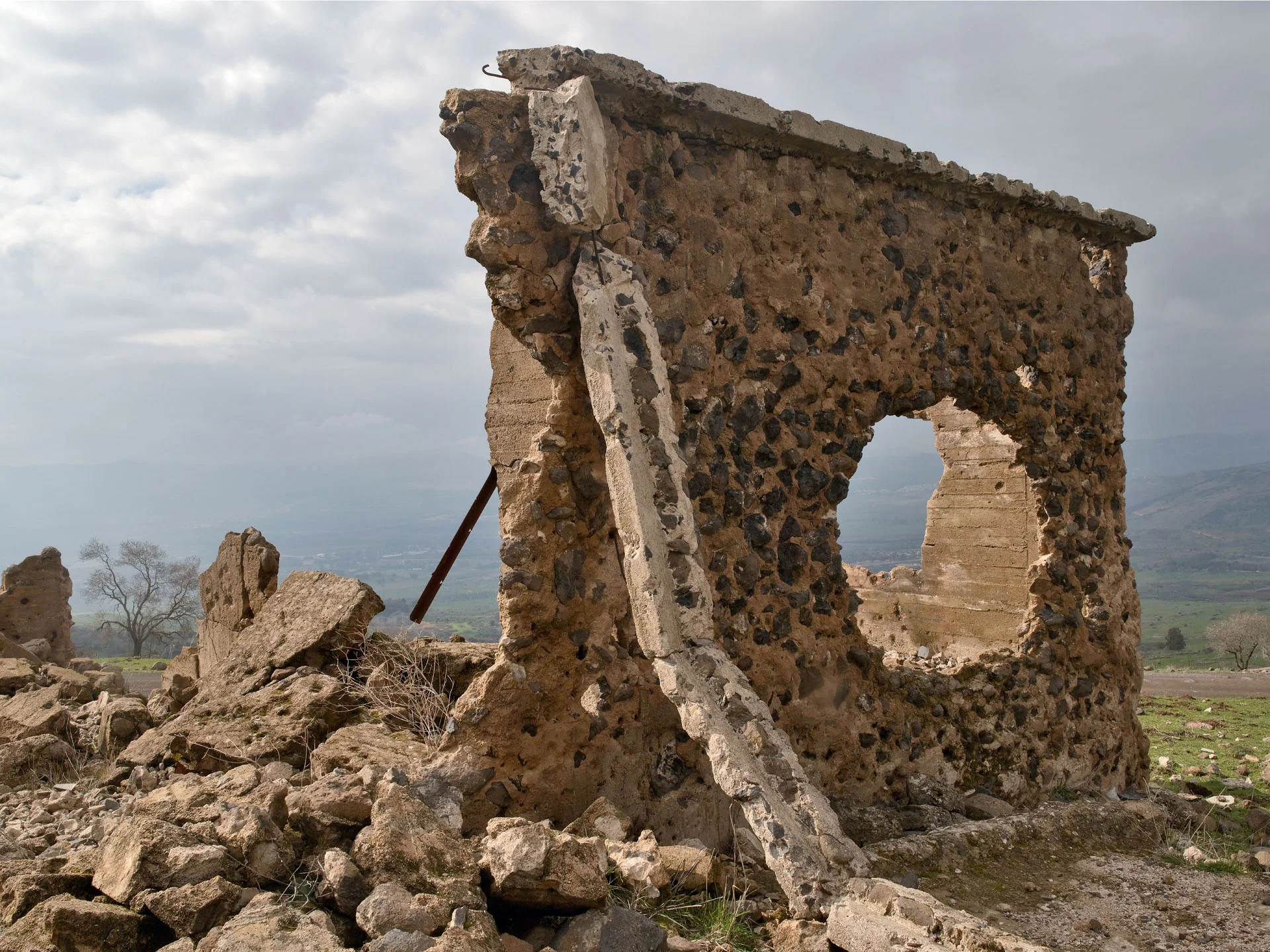
During WWI, Kalya was a Turkish/German military base. It was taken over by the British during the Mandate period and later used by the Jordanian army. Following the 1967 Six-Day War, Kalya was re-established as a paramilitary Nahal settlement.
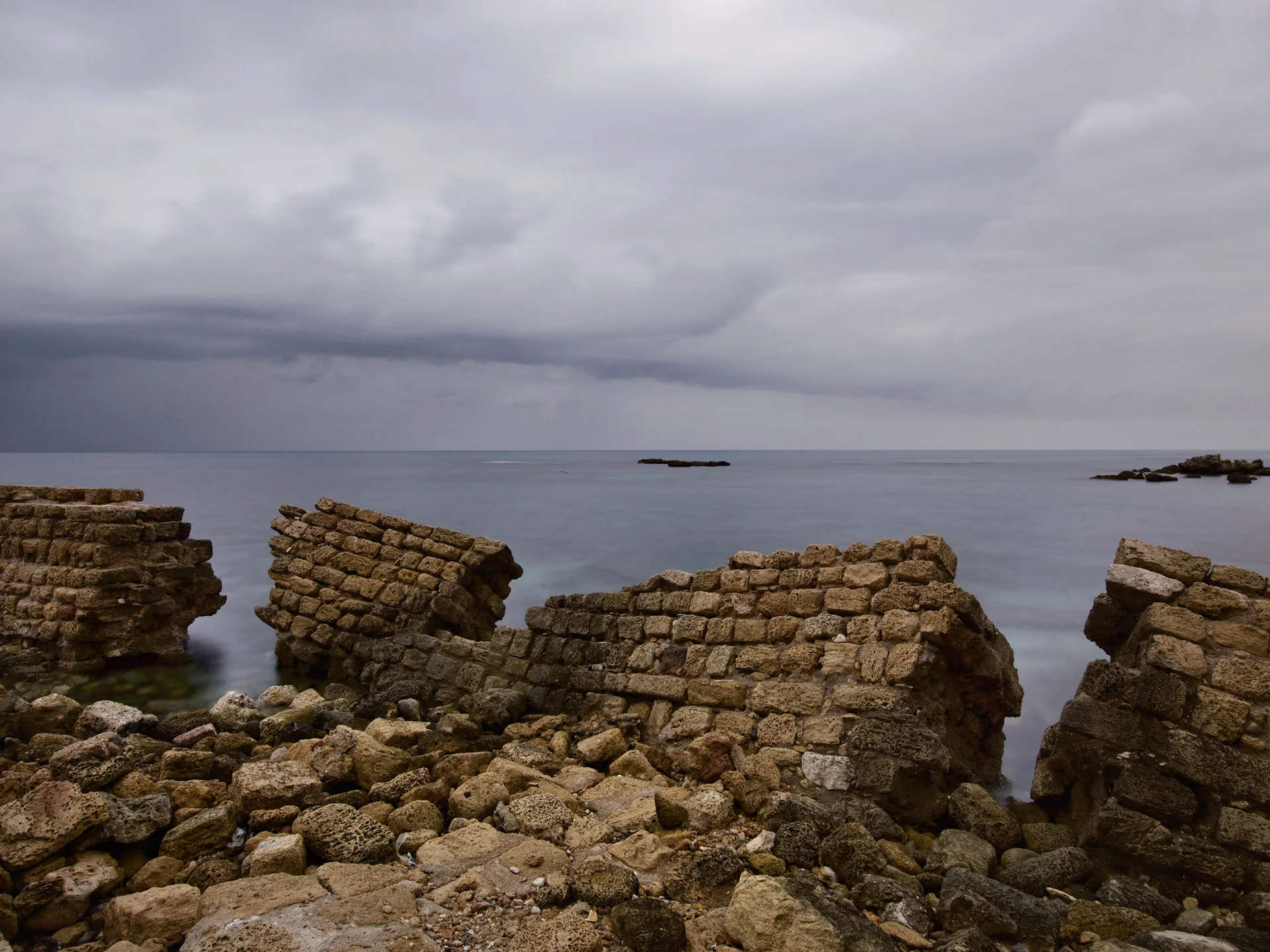
This Phoenician city, built on the shores of the Mediterranean Sea during the Persian Period, was subsequently ruled by the Hasmonean King Alexander Yannai, conquered by the Roman army leader Pompeii, renamed and expanded under Herod the Great, conquered by the Crusaders, and later destroyed by the Mamelukes. Since then, the majority of the site has remained in ruins.
The Arab village of Lifta, which lies near the entrance of Jerusalem, has been abandoned since the Israeli army drove out the last of its inhabitants in 1948. In 2002 construction there began for an emergency tunnel from the nuclear bunker for the Israeli parliament. The tunnel exit is located in “Emek Harazim” under the historical village of Lifta.
Masada is the most famous of the seven ancient forts that create a chain of desert strongholds. Besieged by the Romans in the first century of the Common Era, the entire group of 960 rebel Jews living there committed collective suicide. In 2001, Masada was declared a UNESCO Worldwide Heritage Site.
Lights of the Israeli military base of Shivta can be seen beyond the ruins of the Nabatean city.
This city, established during the Nabatean Period, was occupied successively by Romans, Byzantine Christians and Arabs until the 8th century, when the city was abandoned, demilitarized, and its walls destroyed. In 2005, Shivta was declared a UNESCO World Heritage site.