


Ever since the very first inquiries into photography in the 1830s and 1840s, the natural landscape has been a place where photographers have sought inspiration and solace. The camera is particularly well suited to these pursuits. As both an observational and an expressive tool, it has served
the curiosities of scientists and artists alike. From nineteenth century photo- graphs of ruins in the English countryside to satellite images of the moon, the camera has charted where we have been and has given us a glimpseof what lies ahead.
Landscape photographs also tell of the time in which they were made.In the 1850s and 1860s, British photographer Francis Frith’s photographs of Egypt and Palestine appealed to a curiosity for exotic places when world travel was largely restricted to missionaries, merchants, and the military.1 More recently, Lewis Baltz, Richard Misrach, and others have made meticulously detailed photographs that expose the misuse of the landscape by industry and individuals alike, and Simon Norfolk has photographed war-ravaged landscapes including Iraq and Afghanistan.2 Shai Kremer’s color pictures of contested territory throughout his native Israel employ a similar anthropological and critical approach to photographing the impact of human behavior on nature.
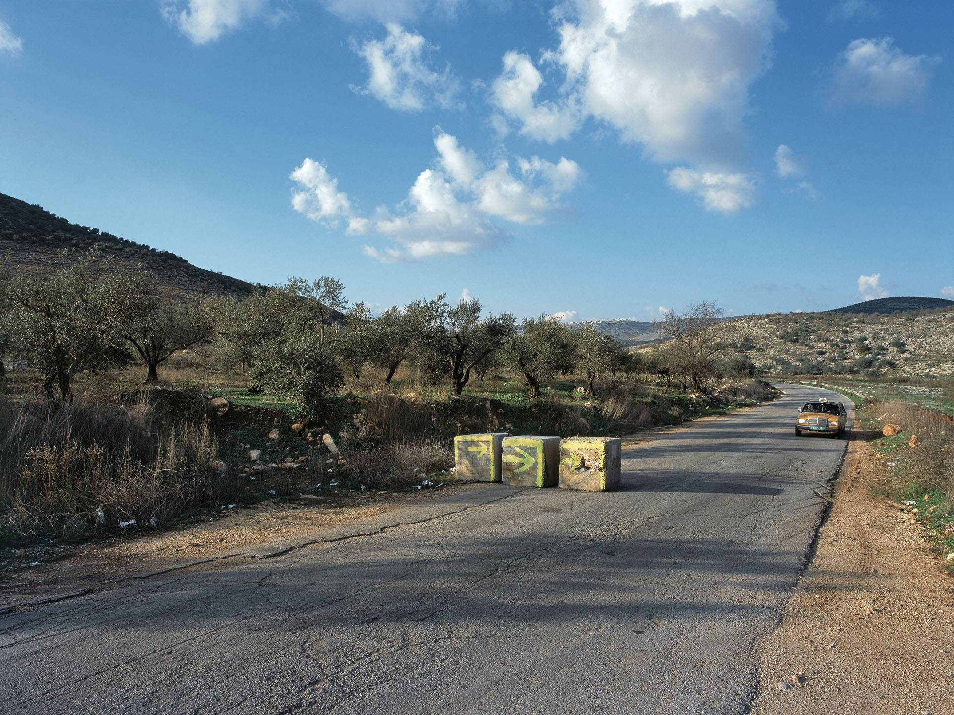
Born in 1974 and raised in Kibbutz Gaash, Kremer began this body of work in 1999, while a student at Tel Aviv’s art school ‘Camera Obscura’. Since then, Kremer has made hundreds of photographs of historical locations, abandoned outposts, and the detritus of war that litters the landscape of Israel. Some places are readily recognizable as military zones, such as the army-training city dubbed Chicago, where troops practise warfare. Others are more ambiguous. Photographs of roads that are unmarked and unremarkable, for instance, do not immediately appear to address Israel’s control and blockage of movement in occupied territories. Only the titles locate the pictures politically or geographically. As example, in a seemingly pastoral image, what at first looks like rolling hills covered with lush green grass is identified in the title as a tank barrier in the Golan Heights.
The aesthetic Kremer employs with this body of work—some images lush in color and others flat in tone—adds to its complexity. An image of a cement wall construction plant, for instance, is seen from afar and is uninflected by sentiment or beauty. By contrast, a desert scene depicting a rusted fighter
plane that serves as an Air Force training target is photographed with a wide angle lens in golden light, which dramatizes the aircraft’s decay and lends it a presence that is at once heroic and menacing. By alternating between crisp analytical renderings and grand sweeping vistas, Kremer produces a body of work that is rich in contradiction and reflects both aggression and vulnerability.
Kremer considers the landscape as a platform for a discussion of the Israeli occupation. He views the elements that have altered the topography of his homeland as reminders that the landscape accumulates layers of history like successive coats of paint, and he warns that the remnants or markers of warfare may become permanent fixtures in the contemporary landscape. That the landscape bears witness to the events that take place on its sur- face is a centuries-old idea underlying memorial art and commemorative architecture, from Saint Peter’s Basilica to Jerusalem’s Wailing Wall. With that in mind, Kremer’s pictures may be seen as a memorial of sorts, to
the dream of coexistence and peace perhaps? At the same time, they provide evidence of resistance and resilience. In a photograph of a defense wall surrounding the Jerusalem neighborhood of Gilo, a mural made by residents reclaims the landscape beyond, as if in defiance of political and military intervention. Images like this express not only the social and philosophical concerns of the artist: they may also be seen as reflectiveof the human spirit. Human beings have battled for territorial dominance throughout history and across cultures. And yet it is how we treat the landscape that is the truest test of our courage and compassion, and the most accurate measure of our nature.
1. Frith made three photographic expeditions to Egypt and Palestine between 1856 and 1860. His photo- graphs were circulated in books published by James S. Virtue and William Mackenzie, London, between 1858 and 1865. See Van Haaften, Julia. ‘Egypt and the Holy Land’ in Historic Photographs: 77 Views by Francis Frith. New York: Dover Publications, Inc. 1980.
2. Starting in the late 1960s, Lewis Baltz, Robert Adams, and others used medium and large-format cameras to produce precisely detailed images of America’s highway oriented culture and suburban sprawl. Additional photographers who have turned a critical eye on industrialization, warfare, and the impact of human behavior on the landscape include Emmet Gowin, David Hanson, Gilles Peress, Simon Norfolk and John Pfahl.
One of the clearest manifestations of the oppressive dimension of the ‘human condition’ is human civilisation’s presence in the natural landscape, and man’s dominion over it.
This problematic is one of the key themes addressed by modern thinkers, and it is most concisely and finely articulated in Horkheimer and Adorno’s thesis, The Dialectic of Enlightenment. Man’s dominion over nature, as this thesis argues, was always a precondition for the founding of any civilization – a necessary act meant to liberate man from the threat of nature and from his necessary dependence upon it. Biblical myth touches upon this point in the story of the expulsion from the Garden of Eden. It details the shift from a condition defined by a lack of oppressive governance and characterised by the harmonious co-existence of man and nature – to one in which man becomes the lord of the land, yet pays the price of this in enslavement to a gruelling life of toil. The Dialectic of Enlightenment addresses this problem- atic with a basic, trans-historical argument: man’s tyrannical mastery over external nature was, from time immemorial, inseparable from his internal self-control, which in turn implies man’s tyrannical mastery over his fellow man. This inherent connection between man’s control over nature, self- control, and the oppressive control of the Other reveals oppression to be
an essential dimension of the civilising process. By extension, it reveals the institutions of civilisation to be manifestations of an oppressive force which is embodied within human practice, and which reveals itself in nature.
Human oppression has numerous manifestations, bifurcations, and embodiments. One comes across them every day, even in the seemingly non- eventful realm of a quotidian life devoid of sensation and violence. Suffice it to think about the ‘natural’ brutality of the modern metropolis. This
may evidence itself in the external forms of modernist urban architecture, and no less importantly in the implications of this architecture for the human life teeming within it – implications which include alienation and estrangement, neglect, and the other forms of human suffering. Clearly, this brutality acquires horrifying qualities on a completely different scale in times of emergency, such as natural disasters or, more particularly, acts of terrorism. Yet horrific violence on such a scale is unusual; in general, it is relegated to extreme contexts and its examples are rare. Yet as a threat – as the ever-present possibility of a retreat towards a kind of barbarism – it infiltrates urban landscapes and is gradually institutionalised as a complex
of architectural forms that respond to it. Nowhere is the long arm of contemporary terrorism revealed in a more bitter and ironic manner thanin the various forms of barriers and fortifications placed at the monumental façades of hotels, embassies, and other public buildings; these buildings often resemble medieval fortresses rather than sites within a modernpublic sphere that prides itself on its freedom. This imposed architectureof security systems seems to attempt to veto the monumental aesthetic of the buildings and, in doing so, it exposes the quintessentially ideological dimension of ‘the war on terrorism’, and of the related narrative concern- ing the modern crusade of the ‘free world’ against its enemies, who are scattered throughout the world and arrayed on the ‘axis of evil’.
The oppressive dimension of the relationship between nature, civilization and violence finds its clearest, crudest, and most obvious expression inthe context of territorial conflicts; and there seems to be no more suggesive manifestation of this oppressive dimension than the phenomena of occupation that penetrate the lived texture of the Israeli-Palestinian conflict, and which are visible throughout its urban and rural terrains. It is with good reason that Shai Kremer chose to document these manifestations
of oppression. The landscape is indeed infected – infected with the virusof an occupation that aims to control and reshape it, and to change it according to its oppressive needs. It is also contaminated by the oppressive presence of the occupier, who governs out of anxiety and is anxious as a result of so much governance, and who strikes terror in the victims of the occupation. They, in turn, threaten him to the point that he desires to distance them from his life by increasing his control over them, imprisoning them, casting them out, erasing them from his consciousness – and, to this end, interfering in the landscape itself, submitting it to the oppressive logic of ‘security needs’ and to the occupier’s own ideology of tyrannical mas- tery. There are no limits – no limits to the area of the state of Israel; no limit to its growing desire to settle the land; no limit to its power of invention as it creates new means and technologies to perpetuate the very entity whose effects the state must defend itself from: the occupation. It creates roads and bisects the contours of the landscape according to the logic of these roads, which is a by-product of the logic of occupation; it produces gigantic concrete blocks fortified with iron and sets them down as road barriers on those same roads; it fortifies its settlements and surrounds
them with bulky piles of rocks; it circumscribes ‘closed military areas’ with barbed wire and threatens the life of anyone who ‘damages the fence’;it encloses tracts of land and entire areas and locks them behind metal gates; it builds a high separation wall, and cuts off rural populations from neighbouring populations; it constructs intermittently surfaced roads to outposts detached from reality, and ornaments them with decorative electric poles; it is constantly busy with acts of construction that fortify, block, bisect and separate, distorting the natural landscape and moulding it according to its ideology of ‘settling the land’ – an occupying, brutalizing, controlling and oppressive ideology. ‘Forced’ to govern, it forcibly takes this population’s land and zealously devotes itself to violating every- thing that architecture was intended to create since time eternal, since the beginning of civilization: home, domesticity, security, serenity, and peace.
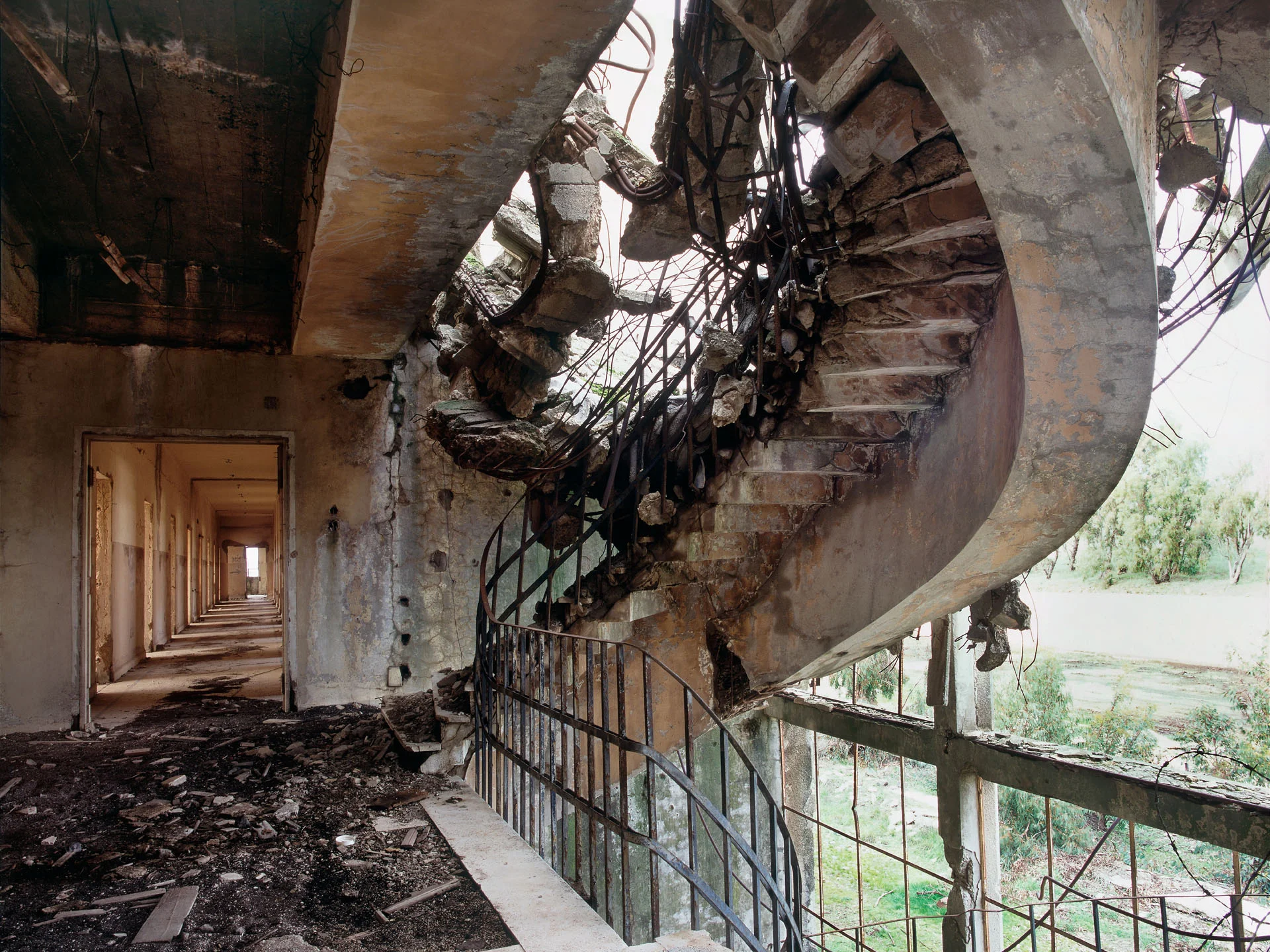
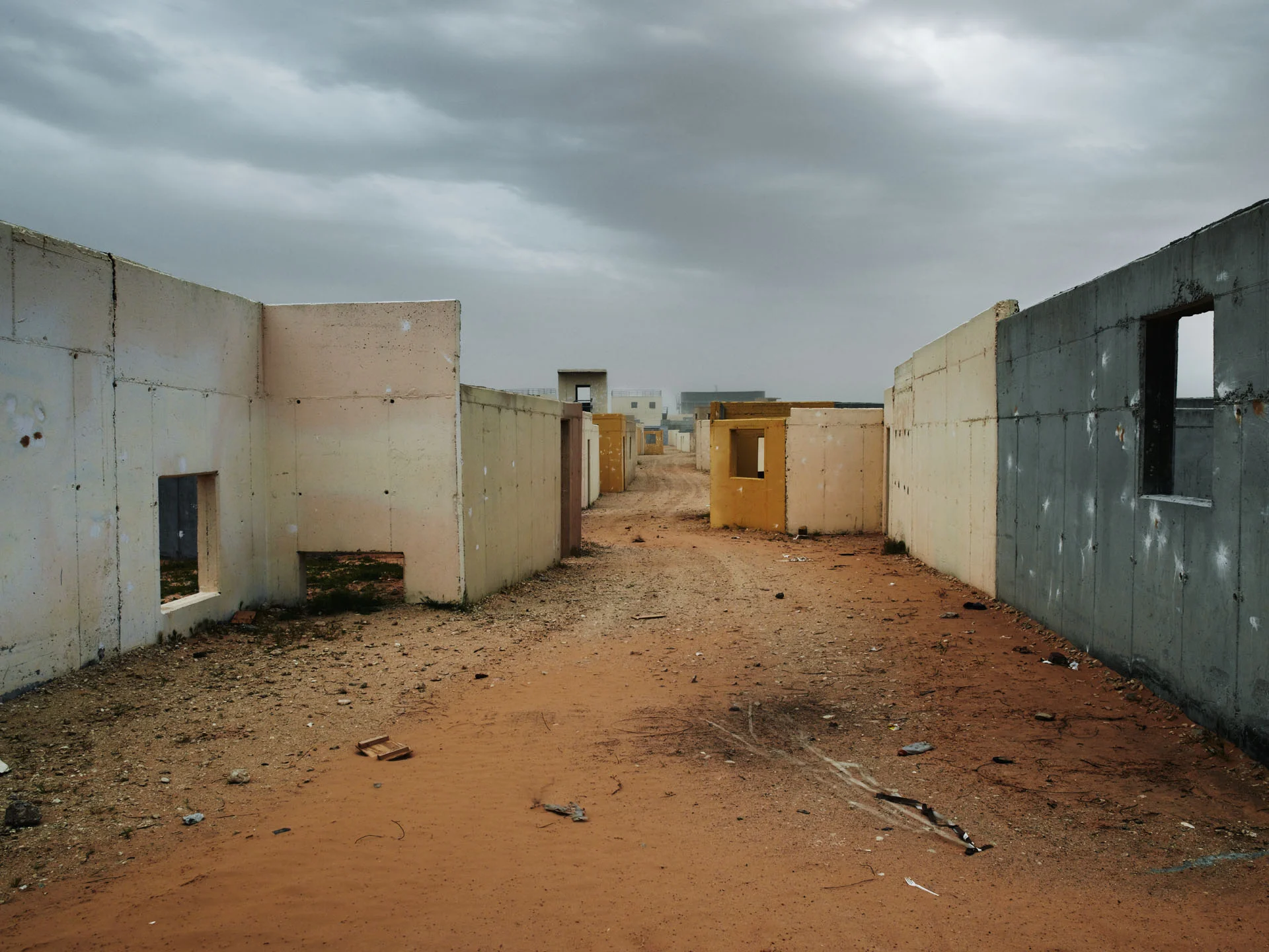
And as if this oppression were not enough – as if there were any further need for cynically illustrating the infrastructure, means and method of implementing the oppression – training facilities of military barbarism are built upon the already tortured land, practice grounds for the violence of occupation. They appear as architectural ruins of deserted military camps, terrifying in their colourful beauty like idyllic ruins, or as stoic remnants of the means of destruction now used as practice targets, with the aesthetics of ‘memorial sites’ commemorating the effectiveness of devastation. But sometimes they actually appear as the reality of the ‘imagined’: as physical simulations of entire Arab villages, inside which the potential takeover
of real villages, and their destruction when necessary, is practised – an architectural creation for the purpose of practising the destruction of an architecture populated with life – civilizatory constructions, as simulation sites for destruction.
Indeed, this is an infected landscape – infected by the dominance of a repressive, inhuman occupation. A landscape praised by its occupiers for the sanctity of its lands – and saturated by its occupiers with the pollution of oppression, with endless human suffering, as well as with the death of the hopes of a home and of homeliness, safety, tranquility and peace.
The olive tree is an image strongly associated with
Palestinian and Arab identity, as well as being a symbol
of peace. The official emblem of the state of Israel also
incorporates two olive branches. This appropriation
of the olive tree by both cultures highlights both the
similarity and the divergence of two peoples and
histories, struggling for control over the same land
In the late 1960s and 1970s, Israeli Air Force Skyhawks
were the primary ground attack aircraft in the War of
Attrition and the Yom Kippur War. They carried more
bombs and had longer range than the air superiority
fighters they replaced. They have been superceded by
F-16s but are still used for pilot training.
Tze’elim is in the Negev, the desert region of southern
Israel which makes up the majority of Israel’s official
Southern District.
Ha’Arava is an area in the south of the country
extending about 100 miles south from the Dead Sea
to the Gulf of Aqaba. Largely sandy desert, it is
divided between Israel and Jordan
Every two or three hours, a military Hummer drives
along the Separation Fence, clearing any marks (tishtush)
on the path (shvil) to allow detection of fresh
tracks which may indicate possible terrorist intrusion.
Shvil tishtush, path clearance, was widely used on
the border with Lebanon, and is now deployed along
sensitive stretches of the Separation Fence along the
West Bank and Gaza Strip.
Situated in a high valley in the Golan Heights, Kuneitra
is strategically positioned near the Israel/Syria border.
Former capital of the Quneitra Governorate in southwestern
Syria it was founded in the Ottoman era as a
way station on the caravan route to Damascus.
Kuneitra was almost completely destroyed before
the Israeli withdrawal in June 1974. It now lies in the
demilitarized UN Disengagement Observer Force Zone
(UNDOF) between Syria and Israel.
Described as an ‘advanced dry storage base for the
armed division of the Israeli army’ the value of this
construction project was in the region of $125m and
the client was the Corps of Engineers of the American
Army. Construction began in September 2001 and the
base covers almost 400 acres.
‘Chicago’ was originally built in the 1980s as a training
site mocked up as a Lebanese village.
US forces regularly train at Israeli military bases and
during the first Gulf War American Special Forces
trained at Chicago.
The history of ‘Chicago’ encapsulates the history of the
Israel-Palestine conflict. Over the years it has been
rebuilt to represent different war environments and
reflect varying scenarios – from Lebanon through to
Gaza City. A further area was also constructed to
simulate a refugee camp.
The Urban Warfare Training Center (UWTC) is a mock
city located in the southern Tze’elim military base. It
was unveiled to the press in January 2007, four months
after the end of the Lebanon War. From a distance, it
looks like any Arab urban centre
In some of the houses openings have been created
to replicate those that soldiers leave behind as they
demolish walls in the process of moving through
urban areas whilst avoiding streets and alleys.
The facility is enveloped by cameras, illuminator
locators, controlled street lights and an audio
system that simulates helicopters, mortar rounds,
and prayer calls.
Built by the U.S.Army Corps of Engineers and funded
largely through U.S. military aid, the 7.4-square-mile
generic city consists of modules that can be reconfigured
by mission planners to represent specific towns.
Known as ‘Balladia’ by the Americans – balad, in Arabic,
means village – it is used by U.S. forces as well as by the
Israel Defense Force.
Complete with shops, a grand mosque, a hospital
and a Kasbah quarter, the UWTC even has a
cemetery that doubles as a soccer field, depending
on the operational scenario. For added realism,
charred automobiles and burned tyres litter the
roadways. During training exercises Arabian music
is played in the background.
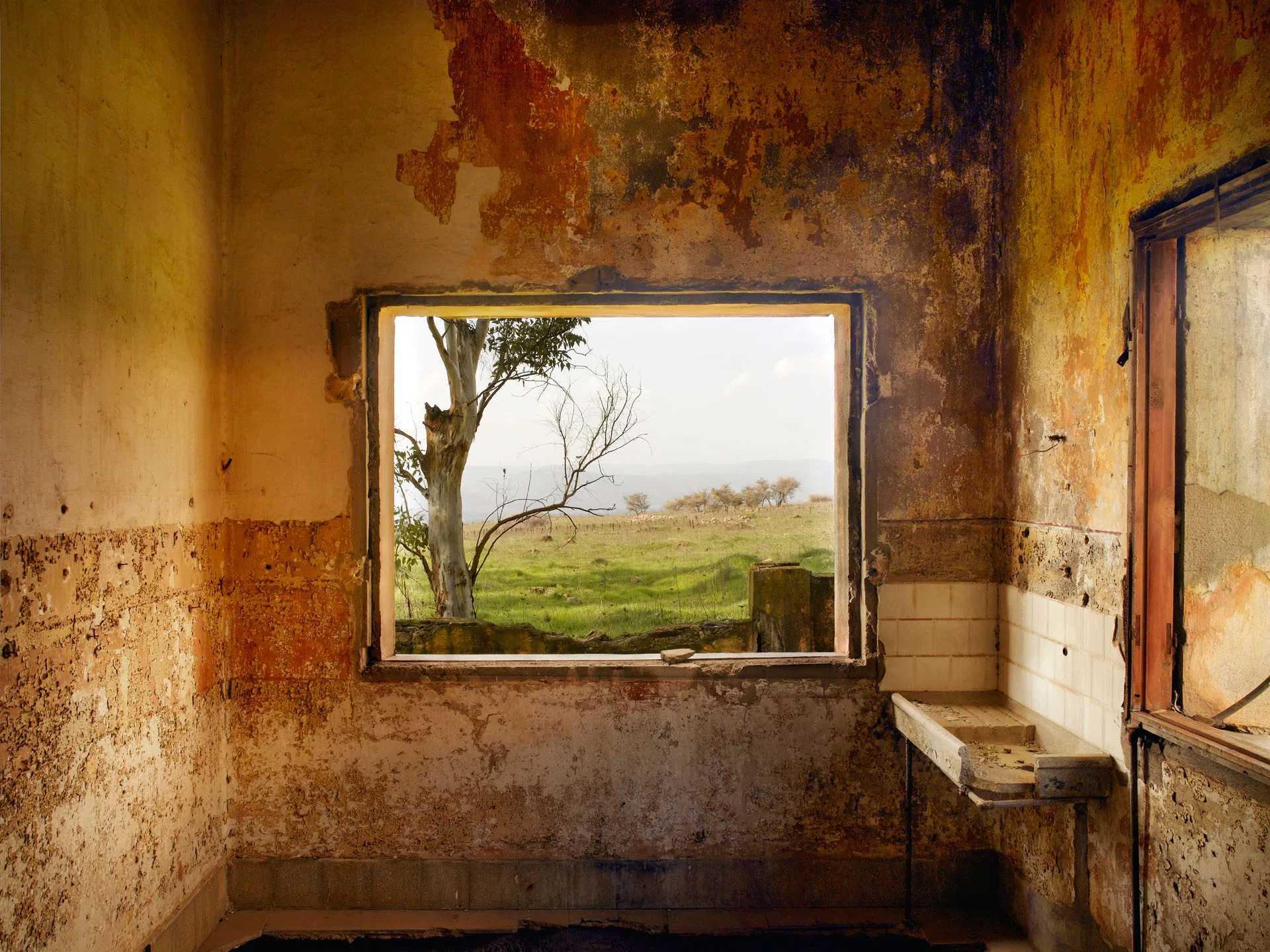
Formerly Syrian territory, the Golan Heights were
captured by Israel in the 1967 Six-Day War. Briefly
recaptured by the Syrians in the 1973 Yom Kippur War,
the area was eventually retaken by the Israelis. An
estimated 80,000 to 100,000 of the population fled.
Shortly after the end of the 1967 war the process of
establishing new Jewish settlements in the captured
area began.
The view from the window is of a minefield. A large
part of the Golan Heights is ‘infected’ by minefields,
remains from the 1967 and 1973 battles